
Modern civil engineering demands precision, efficiency, and adaptability. As construction projects grow more complex and timelines tighten, contractors require technology that delivers accurate results whilst reducing operational costs. Earthworks Trimble has emerged as the industry-leading grade control platform, transforming how civil engineering firms approach earthmoving operations across highways, driveways, and commercial developments. This comprehensive system integrates design files, real-time positioning, and intuitive interfaces to empower operators and project managers with unprecedented control over grading accuracy.
Understanding Earthworks Trimble Technology
Earthworks Trimble represents a fundamental shift in how construction equipment interacts with project designs. The platform connects directly to machine controls, providing operators with real-time feedback on blade position, bucket location, and cutting depth relative to design specifications.
The system architecture comprises several critical components:
- GNSS receivers for precise positioning data
- Machine-mounted displays with intuitive touchscreen interfaces
- Hydraulic control systems for automated blade adjustments
- Wireless connectivity for design file transfers
- Cloud-based data management for project tracking
The Trimble Earthworks grade control platform processes thousands of data points per second, ensuring that every pass of an excavator, dozer, or grader aligns precisely with engineering specifications. This level of accuracy significantly reduces the need for rework and manual grade checking.
Platform Capabilities Across Equipment Types
Different machines require different control approaches. Earthworks Trimble adapts to excavators, dozers, motor graders, compactors, and skid steers, providing tailored interfaces for each equipment type. The flexibility ensures that whether you're constructing a Costa Coffee drive-through or resurfacing a major highway, the technology scales appropriately.

Key Features That Transform Civil Engineering Projects
The earthworks trimble system delivers functionality that directly addresses common construction challenges. Understanding these features helps civil engineering firms evaluate how the technology fits within their operational workflows.
Automated Machine Guidance
Automated guidance reduces operator workload whilst improving consistency. The system calculates optimal blade angles and positions, sending commands directly to hydraulic valves. Operators focus on machine movement whilst earthworks trimble handles fine adjustments, resulting in smoother finishes and faster completion times.
Modern construction engineering demands this level of precision, particularly when working with tight tolerances on commercial developments or residential driveways.
Real-Time Design Visualization
The touchscreen display presents three-dimensional visualizations of the design surface. Operators see their current position relative to target grades, with colour-coded indicators showing cut and fill depths. This immediate feedback eliminates guesswork and accelerates learning curves for less experienced operators.
| Feature | Benefit | Application |
|---|---|---|
| 3D surface visualization | Intuitive understanding of design intent | Complex highway interchanges |
| Cut/fill indicators | Immediate depth feedback | Driveway grading |
| Cross-section views | Accurate slope verification | Drainage channels |
| As-built recording | Documentation for client approval | Commercial developments |
Multi-GNSS Constellation Support
Earthworks trimble leverages signals from GPS, GLONASS, Galileo, and BeiDou satellite systems. Multiple constellations ensure reliable positioning even in challenging environments with tree cover, buildings, or other obstructions. For civil engineering firms working across diverse sites, this reliability proves essential.
The machine control integration enhances productivity by maintaining accuracy regardless of site conditions, weather, or time of day.
Applications in Highways and Surfacing Projects
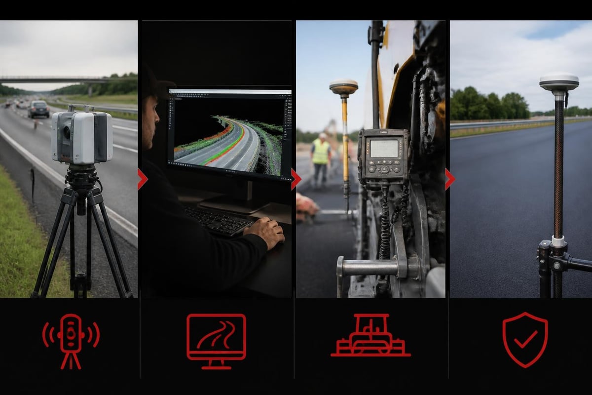
Highway construction presents unique challenges that earthworks trimble addresses effectively. Long stretches of roadway require consistent grades, proper cross-slopes, and precise tie-ins to existing infrastructure.
The system excels in several highway-specific applications:
- Sub-base preparation with millimetre-level accuracy
- Longitudinal slope control across extended distances
- Cross-fall management for proper drainage
- Curb and gutter placement with exact positioning
- Intersection grading with complex elevation transitions
Improving Surfacing Quality
When resurfacing existing highways, earthworks trimble helps operators maintain consistent overlay thickness. The system references existing surface scans, calculating the precise material depth needed at every point. This accuracy reduces material waste whilst ensuring proper structural support and drainage characteristics.
For firms specializing in highways surfacing, the technology delivers measurable improvements in material efficiency and project timelines. Automated depth control eliminates high spots and depressions that would otherwise require costly remediation.
Enhancing Driveway and Residential Projects
Whilst earthworks trimble shines on large commercial projects, the technology brings equal value to residential driveways, patios, and landscaping work. Homeowners expect professional results with proper drainage, smooth transitions, and aesthetically pleasing finishes.
Precision for Small-Scale Projects
Residential driveways demand attention to detail that matches commercial standards. The platform's sensitivity allows operators to achieve:
- Accurate cross-slopes for water runoff
- Smooth transitions between driveway aprons and street surfaces
- Proper elevation matching to garage floors
- Consistent thickness for material optimization
The grade control capabilities prove particularly valuable when working with decorative surfacing materials where thickness variations affect both appearance and longevity.
Client Communication Benefits
The system's as-built documentation provides concrete proof of specification compliance. After completing a driveway installation, contractors can show clients precise data confirming grades, slopes, and dimensions match the approved design. This transparency builds trust and reduces disputes.
Implementation Considerations for Civil Engineering Firms
Adopting earthworks trimble requires strategic planning. Civil engineering firms must evaluate equipment compatibility, training requirements, and workflow integration to maximize return on investment.
Equipment Compatibility Assessment
The platform supports numerous machine manufacturers and models. However, specific hydraulic configurations may require additional sensors or valves. The compatibility with various equipment types ensures most modern machinery integrates seamlessly, but older equipment might need retrofitting.
Pre-implementation checklist:
- Inventory existing equipment make and model
- Verify hydraulic system specifications
- Assess mounting locations for displays and sensors
- Confirm available power supply configurations
- Review wireless connectivity requirements
Training and Skill Development
Operator proficiency directly impacts system effectiveness. Earthworks trimble features an intuitive interface, but comprehensive training accelerates adoption and prevents costly mistakes during the learning period.
Most firms implement a phased training approach:
- Classroom sessions covering system fundamentals
- Simulator practice for interface familiarization
- Supervised field operations on non-critical projects
- Gradual transition to autonomous operation
- Ongoing refresher training for feature updates
The official Trimble support resources provide extensive documentation, video tutorials, and troubleshooting guides that supplement formal training programmes.
Project Workflow Integration
Successful earthworks trimble deployment requires adjustments to established project workflows. From initial design through final verification, the technology influences how teams approach each phase of civil engineering projects.
Design File Preparation
Quality grade control begins with accurate design files. Civil engineers must prepare surface models, alignment data, and cross-sections in compatible formats. The system accepts various file types, but standardizing on specific formats streamlines project setup and reduces errors.
For civils design work, investing in proper design software integration pays dividends through reduced setup time and fewer field adjustments.
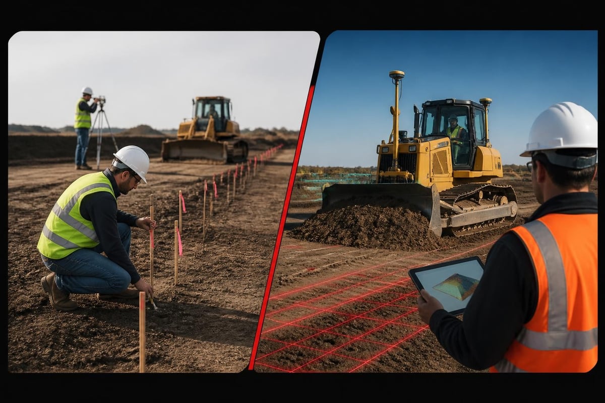
| Workflow Stage | Traditional Approach | Earthworks Trimble Approach |
|---|---|---|
| Site survey | Manual measurements and stakes | GNSS-based surface mapping |
| Design transfer | Paper plans and grade stakes | Wireless file transfer to machine |
| Grading operation | Operator estimates from stakes | Real-time design visualization |
| Quality verification | Manual survey and measurements | Automated as-built documentation |
| Client approval | Visual inspection only | Data-verified specification compliance |
Field Operations Management
Project managers gain unprecedented visibility into field operations. The system tracks machine productivity, identifies areas requiring additional passes, and flags deviations from design specifications before they become significant problems.
This oversight capability proves particularly valuable on large commercial projects where multiple machines operate simultaneously. Supervisors coordinate activities more effectively, preventing conflicts and optimizing equipment utilization.
Advanced Features for Experienced Users
Beyond basic grade control, earthworks trimble offers sophisticated functionality for complex civil engineering challenges. Experienced operators leverage these features to tackle projects that would prove impractical with conventional methods.
Stringless Applications
Working without design files, operators can establish grades using surface references, sensor inputs, or manual entries. This flexibility proves valuable for maintenance work, repairs, or projects where formal designs don't exist. The workflows without design files demonstrate practical approaches for common scenarios.
Compaction Management
Integrated compaction systems monitor soil density in real-time. The platform tracks passes, measures compaction values, and generates documentation proving specification compliance. This feature eliminates guesswork from compaction operations whilst providing verifiable quality assurance data.
For site work requiring specific compaction standards, this functionality ensures regulatory compliance and structural integrity.
Business Benefits and Return on Investment
Civil engineering firms invest in earthworks trimble expecting measurable business improvements. Understanding the financial impact helps justify initial costs and guides implementation strategies.
Productivity Improvements
Automated guidance allows operators to work longer hours with consistent accuracy. Night operations become practical when operators rely on display guidance rather than visual stake identification. Extended working hours compress project schedules, reducing overhead costs and improving client satisfaction.
Typical productivity gains include:
- 30-50% reduction in staking requirements
- 25-40% decrease in grading time per project
- 15-25% improvement in material utilization
- 40-60% reduction in final grade verification time
Competitive Advantages
Firms offering grade control capabilities differentiate themselves when bidding commercial projects. Clients increasingly specify GPS-guided equipment in tender requirements, recognizing the quality and efficiency benefits. The technology enables firms to pursue larger, more complex projects that smaller competitors cannot execute effectively.
When competing for building and civil engineering contracts, documented earthworks trimble capabilities strengthen proposals and demonstrate commitment to quality outcomes.
Maintenance and System Support
Like all sophisticated technology, earthworks trimble requires regular maintenance and occasional troubleshooting. Understanding support requirements helps firms budget appropriately and minimize downtime.
Routine Maintenance Requirements
The integration with different machinery necessitates regular calibration checks, sensor cleaning, and software updates. Most firms establish weekly inspection routines and quarterly comprehensive maintenance schedules.
Essential maintenance activities:
- Daily sensor cleaning and inspection
- Weekly calibration verification
- Monthly software update checks
- Quarterly comprehensive system diagnostics
- Annual factory recalibration of GNSS receivers
Technical Support Resources
Trimble provides multi-tiered support including phone assistance, remote diagnostics, and on-site service. Establishing relationships with local dealers ensures rapid response when issues arise. Many firms maintain spare components for critical sensors and displays, minimizing downtime from equipment failures.
Future Developments and Industry Trends
The earthworks trimble platform continues evolving as construction technology advances. Understanding emerging trends helps civil engineering firms plan long-term technology investments and remain competitive.
Artificial Intelligence Integration
Future releases will incorporate machine learning algorithms that optimize grading patterns based on soil conditions, equipment characteristics, and operator preferences. These systems will suggest ideal approach angles, recommend blade pressures, and predict maintenance requirements before failures occur.
Enhanced Connectivity
Improved cellular and satellite connectivity will enable real-time project monitoring from remote offices. Project managers will track progress, adjust designs, and communicate with operators without visiting job sites. This capability proves particularly valuable for firms operating across large geographic areas.
For civil engineering firms managing multiple simultaneous projects, remote monitoring capabilities will transform project management approaches and resource allocation strategies.
Earthworks Trimble represents a transformative investment for civil engineering firms committed to delivering exceptional results across highways, driveways, and commercial developments. The platform's precision, efficiency gains, and quality assurance capabilities position contractors for success in an increasingly competitive market. At JRG Civils, we combine cutting-edge technology with proven expertise to deliver civil engineering excellence across the North East and throughout the UK. Whether you're planning a commercial development, highway resurfacing project, or residential driveway installation, our team brings the technical capability and attention to detail that ensures outstanding results from initial design through final completion. Contact JRG Civils today to discuss how our advanced capabilities can benefit your next project.